| SHaT1984 | 04 May 2021 6:35 p.m. PST |
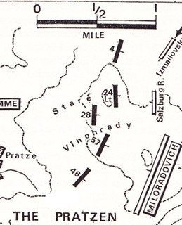
No not the whole thing, yet… Two significant areas of conflict, minor in the parts themselves, but at opposite ends of the battlefield of Austerlitz- the 'vineyards' as we call them, or grape fences? As someone who has studied and researched a fair bit about wines and grapes (growing etc. 'terroir')- does anyone have first hand knowledge of the manner in which these vineyards in Moravia appear, in which direction they pose rows and manner of 'trellising' that may have been used. In the North- Stare Vinohbrady I am surprised actually that so far North on the planet, grapes were growing on the North side of Stare Vinohbrady whereas modern lore makes the sunshine on the Southern slopes more important. Given the 4e de ligne and 24 legere were both protected and constrained by this feature, on slopes, I'd be interested to know the detailled lie of the land. Per Duffys simplified illustration, in the event it was a most significant issue.
I'll note for further interest, given that nothing beyond the ridge from the French side could be seen of enemy. Significant perhaps that no record of Vandamme exists appearing to be in the area of the conflict.
image021Pratzen_©CDuffy Austerlitz-2021. I don't believe the placement of units above is entirely correct as the 4eme were 'mixed' in the vineyard proper adjacent to the 24e Legere according to interpretations. Had they been further away and in the clear likely a better formed square would have been possible. And a more detailled topo map by Thiers, clearly showing the gentler slope of the Northern side--
Austerlitz1805_Thiers_Pratzen. In the South- Tellnitz
Second area, and to me far more important and interesting, is the same features outside to the East of Tellnitz village. A large 'knoll' created by the end of the gentle plain slope coming from the North, East of Sokolnitz, traversed longitudinally by a road approaching from the East, covered in 'vineyard' at least toward the East, and with a cited significant ditch (drainage/ run off) along its Western edge where the slope levelled out to that of the village and the Goldbach fringes and swamp. North of the knoll the ground is gently sloping upwards to the greater plain; to the South it is bordered by a much steeper edge and the great Satchen Pond, therefore an impassable barrier on that contour. Neither side attempted to do anything along that edge, except where it widened to a flat area on the Southern edge of the village. Another simplified illustration from CDuffy--
image027_Tellnitz_Goldbach_©CDuffy.
And Thiers version, slightly muddied because of the scan--
Austerlitz1805_Thiers_Tellnitzby DaveW, on Flickr. The functional area here is that portion of roadway that the Austrian attack came down, bordered by the vineyards where Kienmayers name is, and the ditch at the Western extremity.
Because it was notably used by the French and not an impediment to them, it must have been frozen over and dry as they used it for a second defensive line (the first was the slopes and 'vineyards' cover themselves) until forced back by weight of numbers of enemy attack. Of course one must remember that this was the depth of Winter- grapes were not growing, no foliage present and for all interest, the vines must have been stumps. Why such 'good' terrain in both places for defensive operations? On the Northern sector, I'd place strong emphasis on the vineyards disturbance to 'order' of the 1/ 4e de ligne and their inability to form [defensive] square properly. Your thoughts and/ or photographs greatly received…
regards
davew |
| Cdr Luppo | 05 May 2021 1:44 a.m. PST |
Good day Dave, you might try to ask Jakub S. directly (from austerlitz.org/cz )
he is the one who can perhaps provide such details about "vineyards orientation"
he has also a FB group : link beyond that, there are some detailed maps for Austerlitz at Gallica, but not sure they will provide the precise infos you are looking for .. best regards |
| Cdr Luppo | 05 May 2021 1:54 a.m. PST |
FWIW, the link to the map at Gallica, by Calmet-Beauvoisin in five parts, with a rather possible high resolution (zoom) link best regards |
| SHaT1984 | 05 May 2021 4:03 a.m. PST |
Hi
@Cdr Luppo thanks for the info.
Had not seen that map before. Resolution still not great as pdfs can't scale up, however some readable new information for sure. I can at least understand now the vegetation and scenes if not actual vineyards. I was aware that the austerlitz1805 site had gone but hadn't pursued that area since. Thanks again, dave |
ChrisBBB2  | 05 May 2021 4:44 a.m. PST |
You may or may not glean something useful from the Austrian Second Military Survey map:
link |
| Lucius | 05 May 2021 3:11 p.m. PST |
I'll only try to answer the one question about, "why good terrain for defensive operations", based on one afternoon, spent walking on the Austerlitz battlefield a few decades ago. Take it for what it is worth. It may have nothing to do with grapevines per se. The defensive advantage may very well be because stuff depicted as flat on a map, isn't really flat. I was quite surprised that "flat/clear" areas had a number of minor folds and dips that cut visibility at unpredictable times and places. A foot or two change in elevation, which seems negligible when you are walking it, makes a massive difference in what a human being can see. |
| Cdr Luppo | 05 May 2021 3:58 p.m. PST |
"A foot or two change in elevation, which seems negligible when you are walking it, makes a massive difference in what a human being can see." i agree with that and wonder what can be the solution to represent those ondulations on a wargame map ?! micro terrain ? best regards |
| SHaT1984 | 05 May 2021 4:12 p.m. PST |
@Lucius Thanks for the observation. I'm jealous that you've been there.
I had plans to go, visas etc. but my partner at the time was scared to go behind the 'Iron Curtain' despite our locale in Wien. I am aware of the elevations in general and taking memoirs at face value. I think the point is that at least for the 4eme de Ligne the area and features were a double edged sword so to say; great 'break-up' of clear line of shot when receiving fire; not so great when forced to form square when the cavalry were unleashed. Given all the other squares on the plain to the North, there is something 'unwritten' or being hidden about the sudden demise of the 4eme. Their visibility as being on the higher ground isn't in question. After all the Russians had to attack up-slope as well, which may not have been a major issue to them in the open. It is recorded that they 'entered' the rows of the vinyard to trample the French. Really what happened was a command and control problem in that an unsupported unit should not have been compromised like that. In the case of Tellnitz, I agree as the curve of the knoll would have sufficiently hidden the defenders until a close fire on marching troops/ skirmishers would take effect. That the 3eme voltigeurs (perhaps all 3 companies making a quite dense, and/ or efficient rotation of manpowere) did so for some time before retiring to the ditch after the Grenzers started getting their aim in. I'm looking at creating some portions of the battlefield 'at scale' to represent these faetures in part as so far I've made 'generic' table terrain- time for something more… If you have some, or any photographs of specific areas I'd love to see them. I'll post my 'generic' addy later. @Luppo- I agree and have used a simple roadway, declaring it a 'covered way' or a road depression and having steep banks- (just like a river or stream can- such as seen at Waterlooo). Ideally I will build in the drainage ditch to the Western foot of the knoll and 'massage' the terrain downwards to flat. The other issue @Austerlitz that is THE major obstacle apparently not at all well understood was the broad expanse of swamp/marsh that bordered the Goldbach- making the defiles defended by the French plan just so important (ably aided by the gross lack of initiative of the Allies commanders present of course). But I can easily model plenty of those!
regards d |
| SHaT1984 | 05 May 2021 5:10 p.m. PST |
@ChrisBBB2 Duly noted and purchased two maps necessary for the whole terrain. Splendid detail. Clearly the countryside was changed in the 30 years between battle and survey, but nevertheless very useful.
thanks davew |
| Lucius | 05 May 2021 7:17 p.m. PST |
Cdr Luppo, I'm not sure that more detailed battlefields are the answer. I think that the old tried and true die roll might give you the same result. Maybe rolling snake eyes when you are at point-blank range, with your target caught in the open, sort of simulates that moment when the "flat" terrain you were counting on turns out to be something else. |
| SHaT1984 | 05 May 2021 11:27 p.m. PST |
Welcome to your opinon, just not ours.
This discussion request is about the real, natural geographical location and not some interpretive review of what is and isn't any good for gaming.
I prefer and most players I know prefer good looking terrrain and effects being executed, rather than tumbling dice and ignoring the realities of what happened there.
-d |
| ChrisBBB2 | 06 May 2021 3:11 a.m. PST |
Well, there is also the First Military Survey:
link I suggested the Second initially because it is a little more precise. On the "level of detail" issue in games: it's a question of granularity, I think. The lower the level of game, the more detail you need. I do think that tabletop wargames in general tend to have too little terrain detail, but it is also possible to have too much. |
| just joe | 06 May 2021 7:57 a.m. PST |
in which direction do the vines grow ?
my opion is the 4th did not form their square in time
and lost their eagle and over run by russian horse guard |
| Stoppage | 06 May 2021 12:57 p.m. PST |
Vineyards are on hillsides = difficult terrain
The rows of vines make already difficult terrain impassable.
They also offer some soft cover. Very, very good for your defensive plan and dispositions. Impassable terrain can be covered by small numbers of troops. Witness the Graz business in St Leonhards cemetery.
Rolling snake-eyes to suddenly "uncover" this type of terrain doesn't really cut it.
Now – let's get down to real business – were they produing Tokay/Tokaji? Wiki – Tokaji Wine |
| Mike the Analyst | 06 May 2021 3:01 p.m. PST |
Goetz describes the position about Tellnitz on P122. "Vinyards and orchards on the western slope of the hill facing Tellnitz". This hill to the east of Tellnitz seems to have been high enough to mask the village from artillery fire. Also P226 Vinyards on the heights northwest of Krenowitz, impassable to guns. These heights continue on to Stare Vinhodrady |
| SHaT1984 | 06 May 2021 3:50 p.m. PST |
Thanks guys- while i'm not disagreeing with anything, what I'm looking for is the 'form' of vines- they didn't use 6 foot high Number8 wire trellising on 4" round treated posts as we do in NZ now, so WHAT DID a Moravian vineyard look like? Knowing how some of the oldest vines in Burgundy look and grow, through repeated cutting back, they are maybe 2 foot high stumps of solid timber up to 4-6" thick; how densely grown, what surface they have (ie stones?) grown in etc… Yes Mike, the Grenzer came down the much gentler slope (roadway) from Augezd height; gentle as the Littawa runs adjacent South of it, where that portion of the plain merges with the slope also coming down'hill' from Sokolnitz. That bump from the Sokolnitz side protrudes into and creatng the 'knoll' effect immediately East of Tellnitz; which is why the grenzer were then going 'uphill' and came into contact with the deployed volitigeurs in the 'vineyard'. Remember also that this ground had been held by the Austrians and that grenzer and hussars had a 'patrol' scout the village at 3am prior to this main advance being made at 0700. That patrol was why the French suddenly beefed up the defense of the village- as it contained only one battalion of the 3eme and a single company of 'scouts' from the Bataillon Tirailleur du Po. legrand informed that such a probe had taken place, hastened to two other battalions of the 3eme to the village. It appears all 3 voltigeur companies were 'detached' as tirailleur into the vineyard and forward slpe before 0600. d |
| SHaT1984 | 06 May 2021 5:25 p.m. PST |
in which direction do the vines grow ?
my opion is the 4th did not form their square in time
1- I'm open on that joe- per ChrisBB* second (First) survey map, we get a 'feature' on the Stare Vinohrady vineyard perhaps that one quarter of the clock- 12 till 4 almost exactly, on the North and NE face of the point.
What is equally surprising is the key used- a post with a vine wrapped around it!
detail of Stare Vinohrady pre1800_ 20210507 – on Flickr. Good stuff for my venture! 2- Why not form square in time. I'm not 100% sure on the direction of the attack/ charge of the great horses- but as this map shows, it is a clear nearly 2 kilometres between the mid position of the I/4eme de ligne and the edge of the reverse slope up which the Russian came.
detail distance from SV to reverse slope 20210507-32 by DaveW, on Flickr. 2kms is a long way, even more if they'd come from the NE quarter and clearly visible. Now why wasn't a formed square not formed quicker? ~d  |
| Cdr Luppo | 07 May 2021 1:17 a.m. PST |
Hi Dave, a sample of a Moravian Vineyard state (in winter ! ) i suspect the orientation is either on a up slope – down slope orientation or right to left orientation .. seems good terrain for troops providing service des tirailleurs .. link toward Agzed point of view .. ? this one might give a sense of the slope, but no vineyard on that picture .. link cheers |
| SHaT1984 | 07 May 2021 2:02 a.m. PST |
Hi Luppo Thanks for those.
Yes any modern vineyard would, not sure of the similarities w 200 years ago. That place was further North than Wien from Brno. For grapes maturation, maximum orientation to the suns direction is in N_S directional, top to bottom of hills (France- Champagne-Burgundy-Bordeaux) and now every other country including New Zealand. German steep hills (Moselle/ Rhine) etc. they are forced to compromise on parapet and terraced horizontal layout.
SO yes you are correct on the layout being 'vertical' not horizontal. The Augezd pics are very telling- the vantage point I'd suspect is as far North as Kobelnitz, looking SE. What is intersting is the steady downward trend of the visible forward slope, decreasing to Telnitz (one 't' OR two) in the sunflower field in front. And the Chapel St.Anthony being on the edge of the Southernmost tip of the Pratzen plateau, above Augezd, were it not for the new trees would be an extremely clear view. Many thanks, copies made ;-)
dave |
| ChrisBBB2 | 07 May 2021 5:24 a.m. PST |
No, in NZ or Chile or South Africa I reckon a north slope would work better … |
| SHaT1984 | 07 May 2021 5:25 a.m. PST |
and that grenzer and hussars had a 'patrol' scout the village at 3am prior to this … In my 3:50pm post I was mistaken writing hussars- in fact it was a zug of the very talented and experienced Chevauleger Regt #3 O'Reilly who rode up to and dismounted, but walked carbines in hand along the dark town streets to locate enemy presence. Apparently taking some of the Tirailleur du Po by surprise and capture. The alarm they raised caused the extension of the defence both in direct units in Telnitz but also increased 'support' along the Goldbach. In fact the 'honour' of leading the first Allied daylight advance on Telnitz was given to the equally talented but much fatigued Hussar Regt #4 Hessen-Homberg. cheers d |
| just joe | 07 May 2021 8:14 a.m. PST |
as i read cognet there was no snow |
| Cdr Luppo | 07 May 2021 8:24 a.m. PST |
the main interest of the winter pics is just to see what the vineyard is like … in winter so, just disregard/forget the snow and eventually concentrate on the vegetation aspect for that season ! best regards |
| just joe | 07 May 2021 9:05 a.m. PST |
i was there in 2005 yes i know but looking toward to the pratzen the
solkolnitz castle in my back looking to vineyard she there any more i could not see the other villages behind this
behind the patzen wil go down steep toward augezd |
| just joe | 07 May 2021 10:13 a.m. PST |
the heights these were called stara vinegardy were they so old vineyard and pratzen heights already?
like now
they are disappeared
when did they disappear?
so stara vine yardy only by name? |
| Cdr Luppo | 07 May 2021 11:11 a.m. PST |
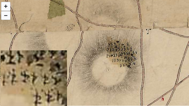
a few views of the The Stare Vinohrady, one the pics at Nap series show the "small hill" link link link link |
| SHaT1984 | 07 May 2021 4:18 p.m. PST |
Thanks gents.
Ok so just the opposite of Waterloo, instead of building a mound, they flattened it. No big deal, modern farming for a century has changed our landscape too… oK joe you're also one up on me!
Just wait, when I win lotto I'll hold a conference there and you are all invited! >>behind the patzen wil go down steep toward augezd
Yes the Chapel is/was poised at the edge of the contour which appears to be the steepest gradient change in the area. Augezd being on the much lower step is invisible from the North.
Makes you understand why the Guard artillery only made it as far as that contour to fire on the Russians; and how they couldn't pull off a 'Balaklava' against them. I understood the context of the pics thanks.
A 'tangible' terrain made for model size bases is going to need some thought. ~d
Thats a great blog too! Wonder why it never showed up in searches- they must use blockers.. oh wait its now guggle owned- must be my ad-tracker-blockers!
|
| SHaT1984 | 06 Jun 2021 5:16 p.m. PST |
Because there are myths, recountered herein, but the thread from 2007 contain some more useful info, so best not let it go___
"Austerlitz – 2nd Dec: comments on Myth, Truth & Playability"
-->> TMP link
~ d |
| SHaT1984 | 27 Jul 2021 11:53 p.m. PST |
Question Two (ou Deaux…) ANyone who has visited the site know the underlying geographical features and colouration? I'm doing more decorative scenic work on models lately, and while I have lighted my style a lot, using pumice and light soils, and paler grasses than the full on Woodland Scenics of old, I don't actually know what the strata consists of. Yes- It was Winter. And dry underfoot without snowfall for perhaps 36-48 hours. But the water catchment was otherwise quite resilient, which makes me conclude it had a solid rock base. Given that ;- Was it volcanic- probably not. Dark gray to black strata.
Schist? Loose pale greys.
What else, or what did you see?
Thanks in advance…
regards dave |
| pfmodel | 28 Jul 2021 2:39 a.m. PST |
Excellent photo's, I have always wondered how to depict terrain on war games, especially figure games, but in order to reproduce Austerlitz you end up with a scale of 1:10000, or if you have a 8'x 6 playing area 1:5000 ground scale, so it gets hard to depict any detailed terrain. At that scale you have to build in minor terrain into the rule, such as always assuming there are reverse slops, dips, hills, bushes etc. On the other hand if you are only gaming a small part of the battlefield this all changes dramatically. |
| Mike the Analyst | 28 Jul 2021 2:45 a.m. PST |
Czech Geology map archives here link |
| Prince of Essling | 28 Jul 2021 4:56 a.m. PST |
Hi Dave, You could always try contacting the Tour Guide at austerlitz-battlefield.com who undertakes personal trips round the battlefield for current info.
All the best Ian |
| SHaT1984 | 28 Jul 2021 4:08 p.m. PST |
Thanks all,
my goofed 'Deaux…' deux more like a duck! |
| SHaT1984 | 20 Dec 2021 2:26 p.m. PST |
Just a
Cross reference for continuity… "Austerlitz – 2nd Dec: comments on Myth, Truth & Playability"
TMP link while the subject isn't resolved a few first hand details of topography appear. Appears in The Redux as #244 as well.
- -
regards
davew |