| forwardmarchstudios | 05 Nov 2015 8:36 p.m. PST |
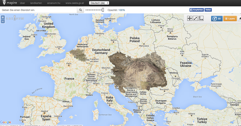
link Ok, so, when you click the map what comes up is an 18th century survey of the Austrian Empire down the the tactical level. This is like the Ferraris maps except that it's been put into a huge google earth overlay so that you can zoom in and out and pan along. The detail is so fine that you can see individual buildings and trees. And, if you click the "3D" button in the upper right hand corner you can place the images over google earth and see hills, valleys, etc. How big of an area are we talking here? [URL=http://s1080.photobucket.com/user/forwardmarchstudios/media/Screen%20Shot%202015-11-05%20at%207.41.41%20PM_zpsxrjmgmuw.png.html]
[/URL]
This means that you could do the entire 1809 campaign and not miss a single windmill… amongst many other uses, I'm sure.
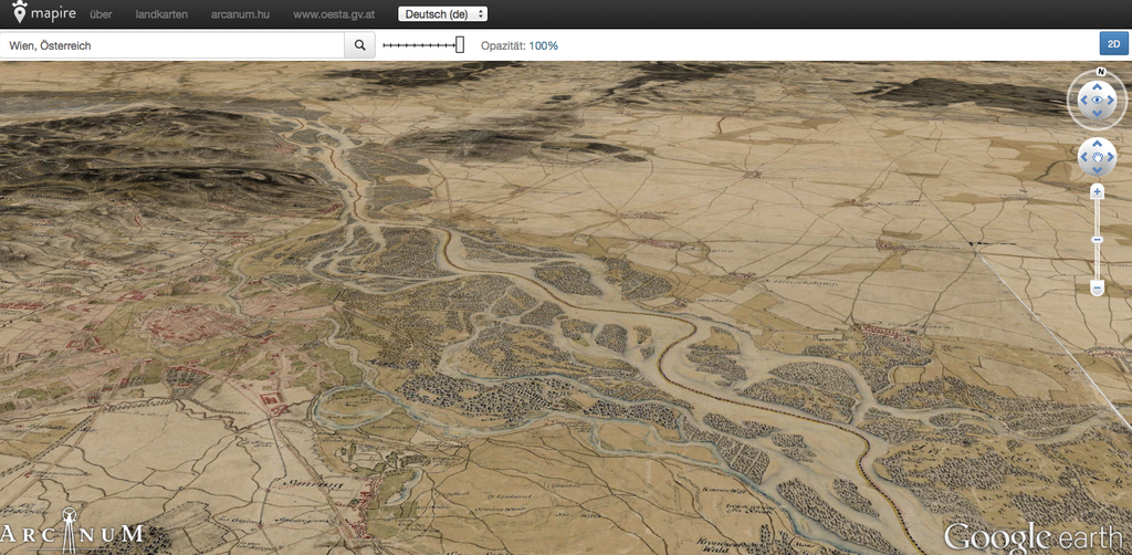
Maybe I'm biased because 1809 is my current project, but I'd put this up there in the top 10 most awesome wargaming tools of all time, after dice, rulers, minis, etc., etc…. The pic below is looking over Vienna towards the Northwest in google earth. You can zoom all the way down and the detail just gets better and better. [URL=http://s1080.photobucket.com/user/forwardmarchstudios/media/Screen%20Shot%202015-11-05%20at%207.35.30%20PM_zpslxs0oqaq.png.html]
[/URL] Also, because it uses google earth, it's searchable, so you can find your way around it super-fast. Just search for Vienna to get oriented. Props to Wee Wars for putting it in my head to search for this stuff. EDIT: And in one of the most incredible twofers of all time, you get the Ferraris maps of Belgium on the exact same overlay. They have a weird grid pattern on them though. Weird, because that's not on the other website. Well, anyway, I'm not going to nitpick it… |
| forwardmarchstudios | 05 Nov 2015 10:05 p.m. PST |
mapire.eu/de Ok, here's the front page. You can actually choose from several different surveys, so you can compare them and watch the march of pseudo-modernity as it crept across the Austrian countryside… |
| TMPWargamerabbit | 05 Nov 2015 11:03 p.m. PST |
|
| Navy Fower Wun Seven | 05 Nov 2015 11:22 p.m. PST |
Looks fantastic – be a great resource for our Wagram Megagame next year… |
| CATenWolde | 06 Nov 2015 2:22 a.m. PST |
Thanks! I'd love to see this for northern Italy. |
| Rittmester | 06 Nov 2015 4:15 a.m. PST |
Simply Great, thanks for sharing! |
| daler240D | 06 Nov 2015 7:58 a.m. PST |
really, really cool. what a great resource. |
| Camcleod | 06 Nov 2015 8:35 a.m. PST |
Here is another set of maps of the Austrian lands done around 1910:
link |
| Jcfrog | 06 Nov 2015 12:21 p.m. PST |
Now cigarbox will you use it do a ( varying scalable?) Wagram/ Essling map?( maps) This is both smashing and…awful as we will feel guilty of doing poor renderings of the real grounds as nonexcuse. |
| forwardmarchstudios | 06 Nov 2015 1:29 p.m. PST |
Lots of possibilities with this, especially for campaign games. You could plot march orders and the like, choose your own battlefields, show operational to tactical movements, and more. A game master could use a few print offs from here to set up starting positions too, while keeping dverything jn context. Theres a built in distance measuring tool as well, so you can constantly keep scale/ arty range, marching times in order. The Ferraris maps were nice but this presentation of the maps, over such a large and relavent area really presents some oppurtunities. Theres probably a way to play a wargame using only these maps, for instance. Brainstorming time! |
| marshalGreg | 06 Nov 2015 1:57 p.m. PST |
Very good find! well done forwardmarchstudios! MG |
| forwardmarchstudios | 06 Nov 2015 5:02 p.m. PST |
Thanks! One interesting take-away already. By using the little measuring stick tool I saw that Aspern and Essling are 900 and 500 meters at their widest points, respectively. This would make them good candiates for my 3mm forces. For me, 1 foot is about 500 meters. It's also very useful being able to see where BUA foliage was and wasn't. This has alreayd taken a lot of guess-work out of my hands! BTW, would the large red building with a wall around it on the western edge of Aspern be the granery? |
| WeeWars | 07 Nov 2015 2:11 a.m. PST |
I did my own version of an Aspern-Essling layered map back in 2012. It has a 500m grid so should be of use to you. link You're looking at Aspern church on the western edge of Aspern. The granary is to the north of Essling. link |
| matthewgreen | 08 Nov 2015 4:23 a.m. PST |
Wow! I don't suppose there is anything similar for Bavaria for the early part of the campaign? |
| forwardmarchstudios | 09 Nov 2015 10:11 a.m. PST |
Unfortunately no, not that I've seen. I misspoke above when I said that you could do the entire 1809 campaign with these maps. Not quite. Still, I'm pretty thrilled with these maps. They should take the verisimilitude of my terrain set-ups to the next level. I just wish there was a way to put down overlays on top of those maps- you could almost play directly on top of those maps. |
| MichaelCollinsHimself | 09 Nov 2015 11:40 a.m. PST |
Thanks for posting this "forward", this is really nice find ! |