| forwardmarchstudios | 04 Nov 2015 10:01 a.m. PST |
Hi All- Just wondering- looking at it today it's all farm fields, but back in 1809 I wonder if it was just open grassland? I know the Austrians used to drill on it, but it's big enough where a few korps could fit up there for drill and still leave any dedicated farmland unmolested. I'm wondering for a big terrain project I'm gearing up for… |
| Navy Fower Wun Seven | 04 Nov 2015 12:11 p.m. PST |
Interesting question! Yes all farm fields when I visited a few years ago, but the thing that struck me was how absolutely flat the whole plain is. |
| 49mountain | 04 Nov 2015 12:27 p.m. PST |
I was under the impression that the Austrian Army used the plain as a drill field, but I could be mistaken. |
| forwardmarchstudios | 04 Nov 2015 1:18 p.m. PST |
I noticed that the road network doesn't seem very conducive to farming, which is why I thought about it. If it wasn't that makes things easier for me! |
 McLaddie McLaddie  | 04 Nov 2015 5:41 p.m. PST |
They were fairly open. They were called the March Fields for a reason.  . They were so flat and hard-baked that the ability to bounce cannon balls down field impressed both sides. There were farms about but the land was used more for grazing animals than farming. . They were so flat and hard-baked that the ability to bounce cannon balls down field impressed both sides. There were farms about but the land was used more for grazing animals than farming. |
| WeeWars | 04 Nov 2015 7:15 p.m. PST |
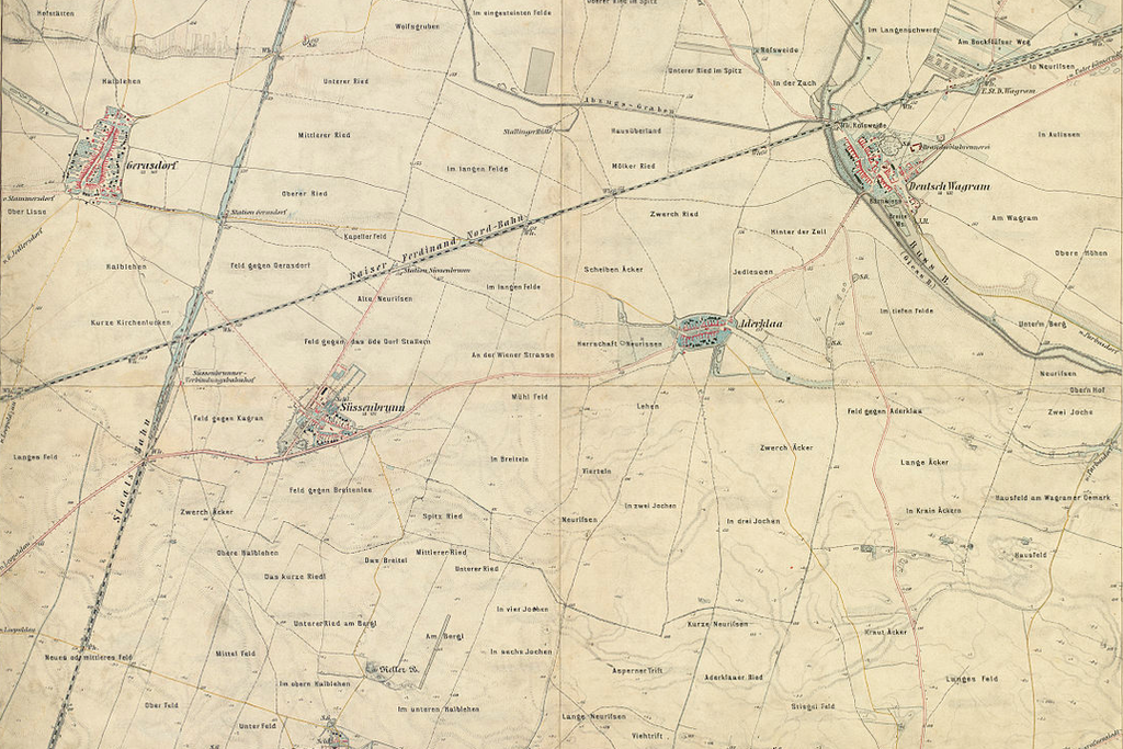
The Marchfeld functioned as a vegetable supplier to Vienna and "granary of Austria". Don't forget the massive granary at Essling. Maps show a web of cart tracks and masses of furrowed fields (and at least one English field!). Like this map, perfect for Wagram's initial manoeuvres.
link
|
| WeeWars | 04 Nov 2015 7:20 p.m. PST |
The March of Marchfeld, by the way, is the river March that drains into the Danube. |
| Kevin in Albuquerque | 04 Nov 2015 8:59 p.m. PST |
|
| forwardmarchstudios | 05 Nov 2015 9:28 a.m. PST |
Great link, thanks! Is there a map panel with the rest of the battlefield in it? I noticed that one is numbered as though it's part of a set. That's a lot of farm fields… hmm… gotta think this through… |
| WeeWars | 05 Nov 2015 11:04 a.m. PST |
I don't think I have, but it would make me very happy when I get round to the Wagram part of the battlefield! The series is late 18th Century so perfect for 1809. Here's the map of Vienna that includes another portion of the Wagram battlefield.
Let me know if you discover the map piece sandwiched between the two! Some links that might aid your search: link link Meanwhile, you could always play a what-if with the existing map and have John arrive early and meet the French head-on as they cross the Danube. There were already plenty of Austrian troops in the area at the time of the crossing. A quicker response from the Hapsburgs could easily have resulted in blocking the French advance around Gross Enzersdorf (Stadt Entzersdorf). |
| von Winterfeldt | 05 Nov 2015 2:27 p.m. PST |
great maps, yes, in case somebody finds the intermediate map, please send the link. As for the battle – field I was under the impression that there were a lot of wheat fields, which started to burn during the battle and by that alas a lot of wounded were burned to death |
| forwardmarchstudios | 05 Nov 2015 7:27 p.m. PST |
Ahh man,
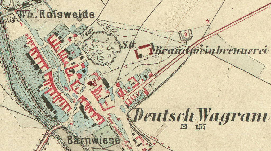
Thanks for the tips Wee Wars. I started doing some searching and found some awesome later maps of Austria: I can't get the link to work, so just google this for the source file: Aufnahmeblatt 4657-3d Gerasdorf, Süssenbrunn, Deutsch Wagram.jpg It's the wikicommons website too.
Click on the 10,000 pixel resolution and prepare to have your mind blown. That battlefield was flat as all get out- this map shows it down to the meter, every little rise and gully is there. It's a bit tricky to get the image to work as its so big but I was able to do so after a bit of wrestling around:
[URL=http://s1080.photobucket.com/user/forwardmarchstudios/media/Screen%20Shot%202015-11-05%20at%206.22.52%20PM_zpsosc4nq9s.png.html]
[/URL] This is zoomed in very close. Here's the full map. There's a lot more like this one out there. The Austrians did a very complete mapping project of their country between the 18th and early 20th centuries. [URL=http://s1080.photobucket.com/user/forwardmarchstudios/media/Screen%20Shot%202015-11-05%20at%206.51.33%20PM_zps7q1chnnr.png.html]
[/URL] |
| forwardmarchstudios | 05 Nov 2015 8:10 p.m. PST |
Ahh man, you guys are going to love what I just found…. I'm going to post it in its own thread though. This is the coolest thing I've ever seen… |
| McLaddie | 06 Nov 2015 5:45 p.m. PST |
Wee Wars: Great maps. I appreciate the information. I didn't know about the Marchfeld being known as a source of vegatables for Vienna. I was under the impression that the March River was renamed after the area had been used for army maneuvers for several decades rather than the other way around…. I understood that a good portion of the Marchfeld, particularly to the north around the Rossbach was used for raising horses. I also understood that by July with the Austrian Army repeatedly marching over the area, that many fields were well trampled. Regardless, it was a hot summer and the ground was hard… |
| WeeWars | 07 Nov 2015 2:25 a.m. PST |
The river is the main river of Moravia, which derives its name from it, being known there as the Morava, a name associated with 'waters'. The German name March refers rather to Mark, as in border or frontier as with the English march, a border region. The lower part of the river has often been used as a frontier it marked the eastern boundary of the Carolingian Empire and was even part of the Iron Curtain. |
| McLaddie | 07 Nov 2015 5:15 a.m. PST |
WeeWars: Thank you for that. It is amazing the inaccuracies that can be printed up as history and then repeated by blokes like me. |
| Paul Goldstone | 07 Nov 2015 9:46 a.m. PST |
At this time Europe practiced open fields agriculture, so fields were generally not enclosed by hedges/walls, so it was very open. Rotation meant a mixture of fields of grass/clover pasture, wheat, turnips, barely, or other crops. |