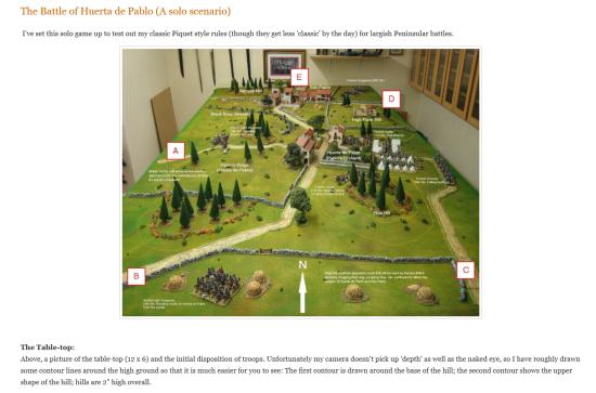
| MichaelCollinsHimself | 19 May 2015 10:03 a.m. PST |
Here are the photos: La Belle Alliance:
Mont St. Jean Farm
(still needs one more little barn added to bottom left):
From top to bottom:
Papelotte, La Haie & Smohain:
|
| MichaelCollinsHimself | 21 May 2015 7:45 a.m. PST |
update:
All the model buildings are completed and primed I made three versions of Papelotte farm, added three smaller buildings to the west of Papelotte. Completed the Mont St Jean farm, using a photo of the Sibornne Waterloo model as a reference. I`ve altered La Haie using the Sibornne maps and I believe that I have corrected the road layout in Smohain. I now need to paint the building models, as these will be inserted/glued to the terrain at the same time as the next big stage modelling the terrain. I think that the modelling will be with mud-earth-coloured filler material and the crop effects will then be painted on the surface as it is for 6mm, the terrain needs this smoother finish. |
| MichaelCollinsHimself | 21 May 2015 12:05 p.m. PST |
Buildings completed primed and undercoated – photos… Smohain – Papelotte:
Mont St. Jean Farm – La Haye Sainte:
La Belle Alliance – La Haye Sainte:
|
| Hohenlohe | 21 May 2015 2:45 p.m. PST |
|
| AppleMak | 22 May 2015 4:59 a.m. PST |
Very interesting project – thanks for sharing. I have been having similar ideas for a more generic battle ground using the wall lining rolls as well. So particularly looking forward to your next missive! Great stuff and very inspiring. |
| MichaelCollinsHimself | 22 May 2015 10:54 a.m. PST |
Thanks for the words of encouragement! Buildings painted and pre-painted thin card tracks glued down with PVA adhesive (the odd white bits will dry transparent):
Papelotte made again – the gate-tower was the wrong way around ! |
| MichaelCollinsHimself | 24 May 2015 3:54 a.m. PST |
The roads and tracks are now completed (the building roof-tiles made lighter too)… Almost the whole table shown here:
Mont St. Jean farm looking towards Papelotte:
On the French side Bella Alliance in top right:
The next steps "cut in" the road edges using either a neutral olive green or dull-brown for the cuttings… … map out the hedges which are on the eastern side
and work out how to make the hedges, woods and orchards ! |
| MichaelCollinsHimself | 24 May 2015 5:09 a.m. PST |
After all is done, I`ll probably get several solo games out of this terrain – at least a replay and some refights a replay of course, would involve the French using the same tactics anyhow and refights would be made interesting with the variations that may be possible on both sides.
Given, as before mentioned, with more support from other French formations and maybe even given different formations on the allied side it seems that a combination of line and doubled line was used by the defenders on the allied side and maybe this too could be varied ? Using my solo rules, a replay would have d`Erlon determining his orders and employing different formations and battle arrays. I think it`s very possible that the weight of the attack should fall upon the Dutch-Belgians as they seem to have presented the most obvious weakened target, having retired just previously. You can find both the solo rules that`ll be using and Grand Manoeuvre games rules at: grandmanoeuvre.co.uk |
| MichaelCollinsHimself | 25 May 2015 8:10 a.m. PST |
After having "cut in" along the road edges and made paper templates for the woods and orchards (I still haven`t quite worked out how to do the orchards btw), I decided to make a start with the coloured wall-filler… Note the line scratched into the filler along the course of the stream that runs through Smohain.
|
| MichaelCollinsHimself | 27 May 2015 11:08 a.m. PST |
I put in a few hours today and I`m just over half-way through texturing and smoothing out the contours !
The brown patches will be covered with woods, whilst I`ll be making bases for the orchards (necessary to fix individual trees) and gluing them into position later.
|
| MichaelCollinsHimself | 30 May 2015 3:00 a.m. PST |
I finished the texturing this morning hedges will break up the battlefield more on the allied left and later I think I can add some different crop colours. The small white patches are the orchards of Mont St.Jean farm and La Haye Sainte.
I`ve also primed the card formers for the wood canopies in a dark green-brown colour.
|
| MichaelCollinsHimself | 31 May 2015 12:27 p.m. PST |
…a couple of photos to show the woods and the hedges on the eastern side/allied left.
|
| MichaelCollinsHimself | 02 Jun 2015 11:39 a.m. PST |
orchards…. these are on frames of cocktail sticks, glued together and primed dark green and brown:
….and with foliage slightly lighter in tone:
I admit they do look a bit rough in close-up, they look OK at a distance, but I may tidy them up a bit. |
 deadhead deadhead  | 02 Jun 2015 12:12 p.m. PST |
This is turning out to be a wonderful project…hard to realise the potential, when we just saw polystyrene tiles! The orchards are ingenious. I am now looking forward to seeing the fields of rye, wheat and corn. Buy hundreds of decorators paint brushes with white/yellow bristles. Dip the tips in superglue and leave then standing upright on your field. Cut across about 5mms above the tips of the bristles, when dry, with a very sharp knife and move on. Repeat across the field until the last stump of the bristles disappears completely. Start on the next brush. It can be done, but it will drive you insane and I might just be kidding……. Siborne, eat your heart out! |
| MichaelCollinsHimself | 02 Jun 2015 12:38 p.m. PST |
Thanks Liam, It would be nice to have all the crops represented on the model. I`m not entirely convinced that the grain crops there would have been quite golden in colour in mid-June I thought that colour comes only in August-September and harvest time. Yep, I think you must be joking about bristle hairs and superglue, but 5mm tall must have been pretty close to the actual figure scale size for the wheat grown then ! I think that it would have been quite useful to have had access Siborne`s drawings or workings out for the model as far as the crop types go anyhow.
I will be using photos of Siborne`s model as reference of course, but I think that some parts of his model are more
photographed than others and the outlying areas will be more "abstract" in nature. Regards, Mike. |
| deadhead | 03 Jun 2015 2:23 p.m. PST |
Oh how right you are. I have tried various techniques to represent such fields in 29mm. Trampled is not too bad, but still upright is murder. Snag is, every time I have gone for ripened crops……..not green. I have never been to Waterloo earlier than late July………now of course I see "how green was their valley" Even then, how do you manoeuvre figures across such a field without ruining your work? I bought some beautiful apple trees for Hougoumont (model railway stuff and not cheap). Loved them and got them home. 'er indoors said "Oh, I love the red apples, but I thought you said Waterloo was in June". Groan. Great work |
| MichaelCollinsHimself | 04 Jun 2015 6:44 a.m. PST |
Now checking to see if I have enough soldiers to play this all… Basing some skirmishers and artillery crews:
Hanoverian and British Brigades:
The best part of the 2nd Netherlands Division:
|
| MichaelCollinsHimself | 04 Jun 2015 8:39 a.m. PST |
Some photos now of the terrain on the allied centre, showing La Haye Saint, the sand pit, Mont St. Jean with orchards… La Haye Sainte to Mont St. Jean:
The Allied centre:
Mont St. Jean:
|
| MichaelCollinsHimself | 07 Jun 2015 4:14 a.m. PST |
…working out where the ploughed field should go using a map from Siborne`s "Waterloo Letters" and photos of the Siborne model:
|
| le Grande Quartier General | 07 Jun 2015 6:04 a.m. PST |
Hi,
I'm afraid my tactical knowledge has a few holes in it. What woud be the tactical deployment used to screen such a position as La Haye if you are D'Erlon and have a division for the purpose? |
| MichaelCollinsHimself | 07 Jun 2015 7:43 a.m. PST |
Hi Robert, I think that the mission would be to take the position of La Haye Sainte, not to simply "screen" the main attack and that this task would be given to the divisional general to deal with…
So, given the resources available, I think also that a brigade would be sufficient to the task and be the level of force used.
It was actually Quiot`s 1st Brigade (54th & 55th Regts. commanded by Charlet) that was given the job on the day.
The rest of the first division could either be held in reserve or be used to support the flank of the second division in the main assault on the allied-held ridgeline. The attack on La Haye Sainte would be made in columns with the brigade`s skirmishers preceding them. |
| MichaelCollinsHimself | 07 Jun 2015 11:26 a.m. PST |
Ploughed fields added;, viewed from the allied left:
|
| deadhead | 08 Jun 2015 2:42 a.m. PST |
Top of the page shows where you were as recently as 19th May…………do you get to bed at night? You'll have to stick "the tree" at the crossroads mind. Then start on the Western half of course, not to mention Plancenoit and Bois de Paris. I love the lower angled pictures because this model does LOOK like the field but gives great insight into how it has developed. There is daft hill for example just west of your margins. Wonder why no one thought to use it in 1815. Mind you I gather it is the spot where P of Or was shot, he should have stayed behind it? Sometime, do show us ground level photos………aerial shots are brilliant. I would think these would work better as illustrations in a book than would maps and contour lines. Much easier understood………. |
| MichaelCollinsHimself | 08 Jun 2015 8:59 a.m. PST |
Oh Yes, Liam… I sleep between painting and gluing things. "The Tree" will be coming along presently and I will try some lower angle shots too. |
| MichaelCollinsHimself | 08 Jun 2015 11:24 p.m. PST |
…almost there working out the placement of the darker green fields:
…you`ll see here that I was mistaken about the positions (and in particular the size of one) of the ploughed fields to the top of the map. |
| deadhead | 09 Jun 2015 8:00 a.m. PST |
Of course, so different now when all the subdivsions are lost and massive fields of a single crop. Not a trace of the hedgerows lining the Ohain road and,as we keep being reminded, crops bred to waste less time in growing so tall….just to be productive and early! I still find it hard to imagine the narrowing influence of Hgmt when the complex was twice the width it now is (with the orchard now fields) Daft question…which you did actually answer in your posting of 26th April, but I am too lazy to do the sums…what is the ground scale? |
| MichaelCollinsHimself | 09 Jun 2015 10:28 a.m. PST |
It`s at the same ground scale as my Grand Manoeuvre rules; one centimetre = 20.94 metres, or 22.91 yards. |
| deadhead | 09 Jun 2015 12:41 p.m. PST |
So I think that means 1/2010 scale….I can't do sums, me…makes you realise. What we call Waterloo was a tiny battlefield. You have reproduced half (a third if we include this idea that the Prussians turned up in extra time)………and what you have made is vast. Try Borodino next………. Seriously though. I keep looking at your pictures and I think the end result beats Siborne hands down. Obviously, if we allow for fading and nearly 200 years and modern technology/pigments/resources, it should be but…the end result is better in your's, now. |
| MichaelCollinsHimself | 10 Jun 2015 12:01 a.m. PST |
Yeah, sales can be such tricksy things ! I think we should say that the Prussians turned up in the second half – and it was a pitch invasion that was later disallowed by Wellington. Poor Siborne ! It is really a beautiful model – you flatter me too much as mine is only a wargames terrain. I`m continuing to work today on establishing those field boundaries and basing the last of the troops that I need for it – Imperial Guard artillery and allied batteries too. |
| MichaelCollinsHimself | 10 Jun 2015 7:10 a.m. PST |
the remaining troops that I needed are based and waiting to be finished off…
|
| MichaelCollinsHimself | 10 Jun 2015 10:02 a.m. PST |
I think this is it for the darker fields…
I will probably get this transferred on to the terrain tomorrow. |
| MichaelCollinsHimself | 11 Jun 2015 6:50 a.m. PST |
The darker green fields added to the Waterloo terrain model… (and some lower angle shots too):
|
| deadhead | 11 Jun 2015 12:40 p.m. PST |
LHS, the sandpit and the hedged Ohain Rd…in that bottom picture. Like being there but without the traffic lights, the shelter, the modern buildings etc. Seeing the orchard back again where it should have been….fabulous. Curiosity and not suggesting it is worth doing for a wargames table, but some sources suggest poplar trees lining the Chausee between La B All and LHS. Were they post 1815 (or indeed, like many features, pre it but removed? |
| MichaelCollinsHimself | 11 Jun 2015 1:30 p.m. PST |
I`ve seen one panoramic illustration that shows poplar trees there may have been the odd trees along that road… what appear to be roadside plantings of poplars are show on other maps and some of these in the Ferraris map seem to have become hedges by 1815 – see below:
Actually checking some other maps I think I have more to add to the eastern side of the table scrubby areas around the stream and through Smohain.
But alas the Siborne model stops at the farm of Papelotte I believe and I have nothing to work from to continue the field patchwork to the east.
I thought I could make something up for that part of the playing surface based upon what`s there now a la google earth? |
| MichaelCollinsHimself | 15 Jun 2015 4:37 a.m. PST |
I`m done with terrain now.. a little pause and I`ll post about any special scenario rules and solo rules for the game. La Haye Sainte to "Wellington`s Tree" with field crop details…
Frishermont/Smohain from the north: showing the Ohain stream, rough pasture and orchard…
La Haie to Frishermont/Smohain from the south…
|
| MichaelCollinsHimself | 15 Jun 2015 5:11 a.m. PST |
One scenario rule will concern the mud… half-speed will be OK, but when moving at normal speeds, there will be a constant chance of disorder… |
| deadhead | 15 Jun 2015 2:23 p.m. PST |
OK, often wondered. Why the sandpit? Cannot imagine the kids from LHS heading there with bucket and spade. Who actually "used" it? Was there a local building firm….or do you need sand for agriculture…..? Finally, when it is all over, what will become of this masterpiece? (which I think it is) |
| MichaelCollinsHimself | 15 Jun 2015 11:48 p.m. PST |
The main road had sand paths by its side, so there`s the use I think. Nope, haven`t thought about what to do with it afterwards. Thanks btw :) |
| deadhead | 15 Jun 2015 11:54 p.m. PST |
How obvious………but for years I have been wondering. Many thanks! |
| MichaelCollinsHimself | 16 Jun 2015 2:07 a.m. PST |
Sandy tracks: on the other hand, it might just be the natural stuff showing through ? |
| MichaelCollinsHimself | 16 Jun 2015 2:09 a.m. PST |
Here are some scenario specific tactical rules for the game. Do let me know if you have any thoughts on them… 1. movement rules:
a) move full and speed risk disorder unit die roll will be made to move/manoeuvre in the mud. b) movement deductions:
i) single hedges = 1/2 turn
ii) double hedges & track = 1 turn. 2. Gun positions along hedge lines count as defiles for troops moving through them. 3. Defensive values for terrain and capacity of areas:
a) single hedge capacity: variable and so limited by space on model
Skirmishers: +1 to die roll
Formed units +1 combat point b) double hedge capacity: variable and so limited by space on model
Skirmishers: +2 to die roll
Formed units +1 combat point c) wood land capacity: variable and so limited by space on model
Skirmishers: +1 to die roll
Formed units +1 to die roll d) orchards w/hedge boundaries capacity: variable and so limited by space on model
Skirmishers: +1 to die roll
Formed units +1 to die roll e) hamlets (lightly built-up areas in the rules)
Skirmishers: +1 to die roll.
Capacity: 3 bases/companies
Formed units +1 to die roll
Capacity: 1 formed unit f) farms (La Haie/La Haye Sainte)
Skirmishers: +1 to die roll
Capacity: 8 bases/companies
Formed units +1 combat point
Capacity: 2 formed units g) walled and enclosed farms (Papelotte/Mont St. Jean)
Skirmishers: +1 to die roll Capacity: 12 bases/companies
Formed units +1 combat point & +1 to die roll
Capacity: 3 formed units. Four of more bases/companies in BUA`s count as one formed unit and only up to three companies will be able to combat with one formed unit.
So, attacks on more than one face of a BUA will split the companies up this should be done as equally as is possible against attacking units. 4. For the replay and d`Erlon`s infantry columns:
In the same manner that open order troops give way to formed infantry; single infantry battalions will give ground to massive advancing infantry formations. The initial distance between the formed units will be maintained as each battalion crosses the double hedges. |
| MichaelCollinsHimself | 16 Jun 2015 8:35 a.m. PST |
setting out the troops…. The allies deployed and awaiting d`Erlon`s attack:
The French left arrayed and d`Erlon is in position at mid-day:
|
| MichaelCollinsHimself | 17 Jun 2015 6:33 a.m. PST |
The massed battery forms up about 13:00hrs… with three 12 pdr batteries from 1st, 2nd & 6th Corps, three 6pdr foot batteries from 1st Corps and Jacquinot`s horse artillery battery; making 54 guns.
|
| MichaelCollinsHimself | 17 Jun 2015 6:36 a.m. PST |
Napoleon & Ney at the Belle Alliance – behind them Lobau`s 6th Corps:
|
| MichaelCollinsHimself | 17 Jun 2015 8:02 a.m. PST |
I`m now making some progress in outlining the forces available to assist d`Erlon… and effectively these are the heavy cavalry brigades on the French right. Because of the restricting terrain, the nature of any conventional assalt in column would have to be deep in nature… 4 units deep; so that brigades would have regiments one behing the other the kind of order that was initially used at Albuera. I did briefly consider a "colonne vuide" (a la MacDonald at Wagram) because it had deployed troops at the front and columns securing its flanks, but I could not determine which troops should form the three faces of such a "column". If you`d like to find out more about the rules being used please visit:
grandmanoeuvre.co.uk |
| MichaelCollinsHimself | 17 Jun 2015 11:22 a.m. PST |
At about 1 PM, Napoleon, anticipating the arrival of the Prussians, moves Domon`s and Subervie`s cavalry brigades to his eastern flank…
Also around 1 PM Jacquinot`s position changes to more directly supporting the left of 1st Corps.
|
| deadhead | 17 Jun 2015 2:21 p.m. PST |
Superb. Your Grand Battery is particularly well shown, as far forward. There seems an idea, all too often, that it was lined up near La Belle All, which would have taken quite a charge by the Union Brigade! A model like this is brilliant at showing the evolving battle. Remember Siborne's work is "frozen in time" I do worry about those lancers. If I was a Scots Grey I would, anyway…… PS The low angle shots….couple more of those please. Helicopter views are more instructive, but the ones you showed earlier…….oh yes! |
Sho Boki  | 17 Jun 2015 6:25 p.m. PST |
Does Domon and Subervie passed Milhaud in front of cuirassieurs? Not rear? |
| MichaelCollinsHimself | 18 Jun 2015 1:56 a.m. PST |
Hi Sho,
How exactly I would have to check perhaps, but this seems to me to be the most direct route, taking one line of march and leading from the front of the column. |
| deadhead | 18 Jun 2015 2:17 a.m. PST |
Well my reply will take you up to 100 and you do deserve it. Still wonder about the ultimate fate of such work. You hit the deadline! |