| forwardmarchstudios | 12 Dec 2013 11:12 a.m. PST |
Hi all, I've been messing around with the Ferraris maps again and found that I can get the ground scale down to where a 40mm base of infantry is exactly 150m in frontage. This allows me to play a really tactical game with accurate period terrain considerations. My intention is to print off about a 10' x 5' table of the map sheets in color and then put them under plexi glass and move the figs and terrain markers around on top of the plexiglass. I noticed while messing around with the map and figs last night that large portions of the Belgian countryside were already quite choked up with small farms and other sorts of development. Indeed, it takes some searching around the Ferraris maps to find a big patch of untouched field where two armies could really have an open area for maneuver. This got me thinking a bit and resulted in some questions. The first question is, say you have a battalion attacking across two fields that are bisected by a row of trees, a hedge row or wall. In order for the battalion to attack in a line formation they would have to split the unit up, one half on either side of the obstacle. Was there an SOP that forbade doing something like this? Or would it preclude the battalion colonel from keeping his troops in hand and was generally avoided? I ask because from messing around on the board it became obvious that there are a lot of small fields that a battalion in a column of division or attack could into that a battalion in line physically cannot, and in fighting in a suburban area this seems like it would give an army that preferred the column a huge advantage tactically over an army that primarily utilized the line. The other interesting thing I noted is that it doesn't seem to matter if one has single-base battalions when playing on a map, since you can just assume that the battalion has changed formation to fit into the situation on the ground. Brigade formations are a bit trickier but can be fudged somewhat. I was also wondering if there are any rule sets out there that allow for both individual battalion combats as well as unified brigade and division level attacks? It seems like this could speed up game play somewhat, as well as being more Napoleonic- allowing the player to commit large units across open terrain for dramatic, fast resolution, vice sending a unit into a built up area where the units can get slowed by terrain and difficulties in C3. Any thoughts? |
| Kleist13 | 12 Dec 2013 12:10 p.m. PST |
There is a reason why troops at that time were maneuvering in column – line is superior as a static defense, and ideally you develop your troops into line shortly before the fire fight, but to get moving you needed to be in column. For example the British Army in the Peninsular often took prepared positions, which allowed them to have their lines well ordered, which worked quite well if the French decided to attack, but meant that they had to move quickly if the French started to maneuver around one of their flanks. For a discussion about the 'new' method of moving in columns and its advantages see for example 'With Musket, Cannon & Sword' by Brent Nosworthy. More available is Hofschroer 'Prussian Napoleonic tactics 1792-1815 which, for example, has a drawing of a battalion in attack column moving through a defile. In the later years (roughly post-1807)many troops had problems moving from column into line and therefore were often kept in column (possibly covered by a heavy skirmishing screen). I think some of the rule system require a die-roll or similar for a successful change of formation (with the possibility to get disordered or similar in case of failure) [Lassalle comes to mind, but you'd have to check, I'm not sure]. Regards, Michael |
| matthewgreen | 12 Dec 2013 1:02 p.m. PST |
There are many more expert than me on this forum, but my impression is that it was quite routine for a troops advancing in line to be confronted with this kind of problem. I recollect a case of a British battalion having to negotiate a small farmhouse at Quatre Bras. In that case the battalion split into two or three sub units which reunited after the farmhouse was cleared. I think units could do quite a lot at company level… Of course, as Michael points out, it was also a reason for using column formations. As well has heavy skirmish screens. At QB the French mainly seem to have used heavy skirmish formations, backed by columns, to attack – with occasional cavalry attacks (I guess on squadron frontage or less) to try and break through. |
| forwardmarchstudios | 12 Dec 2013 1:11 p.m. PST |
So, when it comes to restricted terrain like the aforementioned small fields, would units in line simply not move into such terrain if they couldn't form an unbroken line? Or would almost all armies of the period form into columns and skirmish order to be able to attack? Moving units around on a map of real terrain really brings to light the difficulty of manuevering a unit in line v. a unit in column, and it seems like on a map the rules concerning terrain are a lot more relevent that on most modeled wargame tables, since the latter often lack the general clutter one sees in reality (IMHO…) |
le Grande Quartier General  | 12 Dec 2013 1:31 p.m. PST |
IMHO also- The representations of deployments,tactics, and combat of the period are most often fundamentaly flawed in tabletop wargames that lack a serious devotion to realistic terrain. |
| 138SquadronRAF | 12 Dec 2013 2:32 p.m. PST |
IMHO also- The representations of deployments,tactics, and combat of the period are most often fundamentaly flawed in tabletop wargames that lack a serious devotion to realistic terrain. Well said, I for one tend more towards the 'model railway layout' rather than the 'throw down some piece of felt and call it done' school of gaming. If you take the trouble to make make more realistic terrain you'll get a better game both aesthetically and tactically. |
| Rod MacArthur | 12 Dec 2013 3:41 p.m. PST |
All nations had very similar procedures in their regulations for such avoidance of battlefield obstacles. Basically an advancing line continued to advance, but the part blocked by the obstacle broke up into one or more short columns, wheeled around the obstacle, then marched fast to resume their place in the line. You will realise that this only works if the columns can march faster than the line. This is the main reason why lines habitually marched at a slower pace to columns, to allow such a drill. If the lines marched fast, then any blocked elements could never catch up and the line would become fragmented. Rod |
| forwardmarchstudios | 12 Dec 2013 5:28 p.m. PST |
LGQG/138th, Indeed, a lack of accurate terrain makes me dubious about how some rule sets would function if you were to play them out on a map with more verisimilitude. I need to re-stock on 3mm Napoleonics so I can try out a few different sets. Things are a lot different when you actually have to use roads and paths to move arty and troop formations around. I have a feeling that historically accurate results may be difficult to reach with some, although I might be wrong too. |
| McLaddie | 12 Dec 2013 5:53 p.m. PST |
Was there an SOP that forbade doing something like this? No. The SOP depended on the terrain and circumstances, but a battalion or brigade or division in line could and would split to by-pass obstacles. That is one reason that battalions were also divided into two wings and divisions of two companies…to allow for such contingencies. However, it was slower and made the two parts vulnerable during the maneuver, which is why columns were often preferred. An example off the top of my head of a division spliting two lines of brigades is Leith's Division at Salamanca. The two brigade each split into two parts to by-pass a village in their way. [Can't remember which one.] Napier speaks of spliting his battalion in line in advancing by a village advancing to the battle line at Corunna and later battles also. There are examples of how to do this discussed in Dundas' regulations on the section on 'passing obstacles.' |
| 138SquadronRAF | 12 Dec 2013 6:59 p.m. PST |
Indeed, a lack of accurate terrain makes me dubious about how some rule sets would function if you were to play them out on a map with more verisimilitude. I need to re-stock on 3mm Napoleonics so I can try out a few different sets. Things are a lot different when you actually have to use roads and paths to move arty and troop formations around. I have a feeling that historically accurate results may be difficult to reach with some, although I might be wrong too. Bruce Weigle's 1859, 1866 and 1870 rules and War Artisan's "Napoleonic Command" the way the authors play them would fit that description. Playing over terrain like this helps: TMP link |
| forwardmarchstudios | 12 Dec 2013 8:19 p.m. PST |
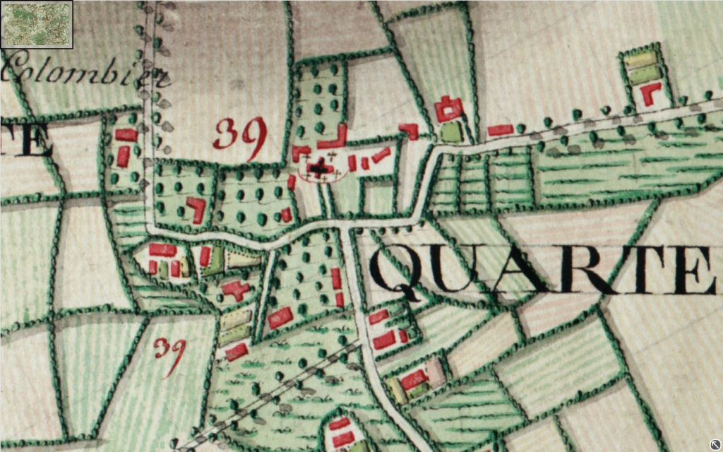
McLaddie, Thanks for the answer, that's what I was wondering in particular- so a battalion in line could/would split itself up due to terrain considerations. 138th- Bruce's stuff is as good as it gets, with the downside being the amount of space required to store all the stuff. What I'm planning on doing is printing out 50 square feet of terrain at this zoom: [URL=http://s1080.photobucket.com/user/forwardmarchstudios/media/ScreenShot2013-12-12at71558PM_zpsbc9ed5c5.png.html]
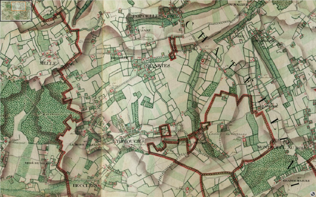
[/URL] But the area that the entire map will cover would show this: [URL=http://s1080.photobucket.com/user/forwardmarchstudios/media/ScreenShot2013-12-12at72122PM_zps04ba83e6.png.html]
[/URL] The second map is roughly 6 miles of finely detailed terrain across. If you just copy the maps at 100% zoom and print them off you get roughly 150m=40mm. You couldn't ask for better war game convenience than that! You'll notice the village in the first pic is roughly in the middle of the second one. The top pic has been resized by photobucket, but I were to print it out that map of the village would be 1 foot across (or 11", technically since I'm printing it on regular paper). Were the village actually a foot across on your computer screen you could hold a 40mm base up to it and that would be the actual ground scale for a battalion of about 700 men in 3 ranks. So by using these maps you can really show a lot, for instance, you could actually set up artillery batteries outside the roads into the town to keep units from leaving, something that you often see in historical reports and almost never on the table top (I have never once seen this). Also, instead of fights for BUAs being totally abstracted, which even most games at the battalion level do, you could fight over towns in a real blow-by-blow manner. My OP questions really concerned terrain like that shown around the village of Quarts- what sort of terrain modifiers and rules would you use for battalions operating amongst those small fields (most of which, at full scale, you could fit a battalion into at least one way). |
| forwardmarchstudios | 12 Dec 2013 11:28 p.m. PST |
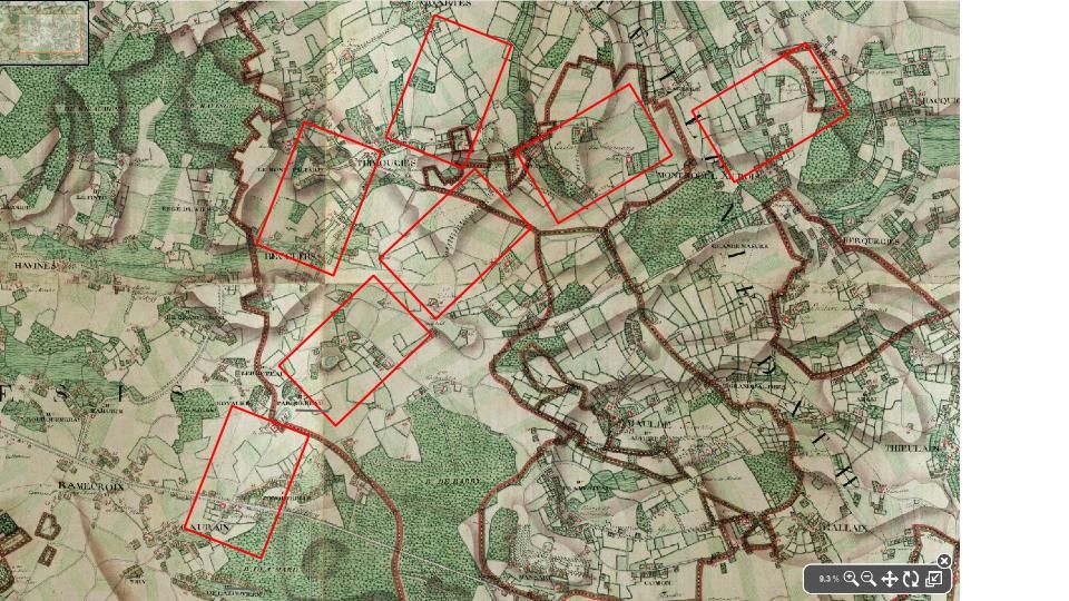
For those who are actually interested in this sort of weird hybrid… I just did a "set-up map" on a potential battlefield using the techniques above: [URL=http://s1080.photobucket.com/user/forwardmarchstudios/media/CorpsDeplyomentZones_zpsb3ba7dd2.jpg.html]
[/URL] The red boxes represent corps sized deployment zones being slightly generous for terrain. If using 40mm battalions then the map would be 10' wide. I assume a division sized reserve for each corps and a frontage of roughly two divisions/1200m. What I like about the map idea is that you can see just how limited sub-commanders knowledge of what was happening around him was. It puts into perspective just how many men and how huge an area a corps commander was responsible for. If you look at the fields in the pic you can see that the middle area of the map is very open countryside and yet it still presents a lot of obstacles that will have to be maneuvered around or dealt with. |
| FatherOfAllLogic | 13 Dec 2013 6:52 a.m. PST |
Interesting stuff. I think in the 'real world' officers would fudge their formations to fit the terrain while trying to conform to standard military practices. As you noted, movement would be slow and confusing. Perhaps this explains how sudden unexpected attacks would throw defenders out of formation and cause them to flee in disorder. |
| le Grande Quartier General | 13 Dec 2013 6:53 a.m. PST |
138/FMS, Napoleonic Command2 that I just procured looks good- and Carnage & Glory allows for detailed terrain and the necessary formation changes to negotiate it as well. I use C&G..the table below is an example of one that it worked very well on. link TMP link FMW, I love your idea of the large printed table cover- so excellent for really easy portable games- I thought I had my 'modlar' railway style down to be easly portable, but that is a super easy alternative- please share the tech details of how you get the large print- I would like to enquire of a local printer if I can do it here :) |
| FatherOfAllLogic | 13 Dec 2013 6:53 a.m. PST |
And yes, wargamers are lazy and don't put down enough terrain on their tables. It makes movement too hard and the formations get all messed up! |
| matthewgreen | 13 Dec 2013 11:08 a.m. PST |
It's quite easy to understand why wargamers tend to put far to little terrain on the table. It's a particular problem for larger scale figures (like my 15mm) unless you have a very big table. And the sheer logistics of getting a good looking table together are daunting. Bruce Weigle spends so much time on his tables that there is none left over for painting his miniatures – and that's an important part of the hobby for many, including me. Still I aspire to do better, and I'm racking my brains on ways to do it with a bit less work than Weigle (and 15mm figures). Meanwhile I think writers of rules need to remember that most of the terrain features are likely to be missing from the table, and build in the friction that results. If I remember rightly the complexity of terrain was one of the main reasons that Clausewitz regarded battlefield strategy as more of a game of chance than contemporary "art of war" theorists allowed. It is accordingly a very big justification for using dice a lot as well as the card systems that are currently fashionable (though I'm not keen on them myself). |
| 138SquadronRAF | 13 Dec 2013 11:31 a.m. PST |
It's quite easy to understand why wargamers tend to put far to little terrain on the table. It's a particular problem for larger scale figures (like my 15mm) unless you have a very big table. And the sheer logistics of getting a good looking table together are daunting. I disagree that it both daunting and time consuming. Yes, it takes time, but it's not that difficult. The table used here is 8x5 and and thrown together in say 20 minutes: PDF link Check out the ATF games from War Artisan, he takes a couple of hours setting up the games: link Now all these games are 10mm and the smaller the scale the more effort you can put into terrain. This set is 15mm: link Are these completely accurate? No,but I would not say they difficult. |
| matthewgreen | 13 Dec 2013 11:52 a.m. PST |
Thanks for posting 138Squadron. I am hungry for ideas as to how to make my terrain look a lot better – and these look good. 2 hours set up is a bit steep for many people – though since I play most games at home, not actually impractical in my case, and certainly repaying of the effort. Everybody should give their table at least 20 minutes, though. |
| 138SquadronRAF | 13 Dec 2013 12:45 p.m. PST |
Matt, Here's how Jeff (War Artisan) and I make the terrain cloths. It's about 25 hours work allowing for drying: link All the materials are easily obtainable. This is how to put together the terrain: link Since these are games are at home we have time. Our public games use tiles and are much more typical of most terrain: link |
| forwardmarchstudios | 13 Dec 2013 9:18 p.m. PST |
LGQG: It's pretty easy… definitely easier than what Bruce and War Aritsan do! I use a mac that makes it even easier because there's a convinient SHIFT+Command+3 screen capture that saves your screen shot right to the desk top. Anyways, there are probably PC versions of this as well. So, first go to the website: link Look through the maps until you find a likely looking spot for a battle. Look in the right hand corner where the zoom button is located. You want to get it to around 10% (the zoom tool can be a bit frustrating) and make it full screen. That 2d part is important. The ten percent zoom will show you what your entire battlefield is going to be, which will end up being roughly 10' x 5'. At 10% zoom you'll be looking at an area 6 miles across. Obviously you could go smaller or larger depending on what you have in mind. In the above example with the deployment zones there would be ~180 battalions of infantry and in addition cav and artillery bases. I'm sure that you could have just as good a game on a 2' x 2' or even a 1' x 1' section of the map for that matter and using a corps or a div per side. You'll probably want to print off a few copies of the entire battlefield for hidden deployments, orders and such. This is another nice feature of using maps over model terrain. After you do that you want to go to a corner of the battlefield and zoom in all the way to 100%. Click the button in the lower right hand corner for a full screen and then hit the X to close out the lower right hand view. Once again, if you're on an Apple just hit SHIFT+Command+3 to take a picture and automatically store it on the desk top. Open it, go to view and hit "Actual size." The pic should fill up the whole screen. Then hit print. Don't worry about the entire image fitting on the paper- all that matters is that it prints out at the same size that it appears on the screen at 100% zoom. Take all the pics you'll need at once. A 10x5 table should take about 80 or 90 pages total… not too bad price wise. When you get them printed off you might use invisible tape to tape them all together. Start from the bottom and cover over the little mini-maps in the corner of each pic. You can get almost all of them out. Alternatively you might mount them onto pieces of foam core to make them tougher, or maybe cut them up so that you can have them laminated. The taped together pieces should go through a laminator with no problems. Then you just slap some plexiglass over them and thats that. |
| tshryock | 14 Dec 2013 8:46 a.m. PST |
Here's another quick method to get decent looking terrain with minimal effort. link |
| matthewgreen | 14 Dec 2013 10:55 a.m. PST |
Thanks for links 138Sq. Fascinated by use of cotton wool to represent hills under the sheet. Much more flexible than sculpted polystyrene, which is what I was thinking of using. Not too spongy I take it? |
| 138SquadronRAF | 14 Dec 2013 3:08 p.m. PST |
Matt The stuffing is great, it does not compress too much and if pinned in down. The filler is stuffing from a fabric store, not cotton wool, which when compressed would not string back. You could also use towels. Elliott |
| 138SquadronRAF | 14 Dec 2013 3:09 p.m. PST |
tshryock Thanks for the link, that also looks good |
| Delbruck | 14 Dec 2013 3:59 p.m. PST |
Assuming a set of rules divides terrain into open, broken, rough, and very rough (in that order of difficulty) – I have always felt that the default terrain should be broken, not open. Open should be considered a special feature on the table, like a dense wood or steep hill. |
| 1968billsfan | 15 Dec 2013 10:22 p.m. PST |
All this is good stuff!! We should also consider the effects that economic and social changes had on the terrain of the day. Were fields getting bigger or smaller? Were the "rich" consolidating small farmer holdings into bigger fields that could be worked more economically? Were the "highland encloser" laws removing small crofters and replacing them with big sheep farms? How much of the land was set up with village common grazing grounds that would be a good place for cavalry charges and how much was repeatedly subdivided into small plots surrounded by hedges that would break up any infantry line? How advanced was the drainage of marshy areas which would provide big flat areas for maneavure? An idea that I don't see considered much is that battles were often only undertaken by some sort of tactic agreement by both sides that each side had a valid chance (to a degree) on that terrain. Both sides might refuse battle, by retreat or further maneavure, if it were not conducive to command and control with the means available to that era. Neither side would insist on a battle in a close swampy area if there were an option- one side would get bogged down and the other might swing around into clearer terrain and create mischief. What I am driving at is that [1] we have to consider the state of the "brokeness" of the terrain in that era and area and [2] with the smaller armies (there was no "western front" from the sea to Switzland) there was a certain selection by the generals as to where to fight a battle. Just more thoughts about terrain. |