Extra Crispy Extra Crispy  | 16 Oct 2016 3:53 p.m. PST |
Looking to do a QB scenario. Looking at the field it seems relatively flat? Rolling but very gently so no real major hills/ridges/elevations? |
 Saber6 Saber6   | 16 Oct 2016 5:55 p.m. PST |
Sounds about right. Most maps have a hill where the French deploy and a ridge that runs behind the stream and along to the west side (and wooded on the West half). |
| Extra Crispy | 16 Oct 2016 6:43 p.m. PST |
Yeah I found a topo map and all the elevations are 2 feet… |
| keithbarker | 17 Oct 2016 1:35 a.m. PST |
I found the following very helpful when looking into QB. Prelude to Waterloo Quatre Bras: The French Perspective
by Andrew W. Field link If you are thinking about line-of-sight, the combination of ridges and high crops will be the challenge! |
| David Brown | 17 Oct 2016 1:53 a.m. PST |
EC, From my recollection, it's certainly not flat, but predominantly a series of low rolling ridges, not very high but enough to block line of sight.
You can see why the French were held up, being unable to ascertain exactly enemy dispositions or strengths. DB |
| Camcleod | 17 Oct 2016 5:48 a.m. PST |
There are a series of East-West ridges running across the battlefield
link
Not very high, but add in the high crops are enough to break up the terrain. |
| marshalGreg | 17 Oct 2016 6:12 a.m. PST |
Disagree on a "flat" battlefield.
Correct It does not have the big hills but it is not flat either! It has many undulations, so visibility is very finite. Then you add in the high crop with a very limited visibility and wallah!There were many units surprised by cav. popping out of low spot, high crops or coming over high spot.
Atkins presents much evidence of this fact! Also if you google map the battle field and use the little guy with a view you can see this for yourself. To present this in play ( and with a double blind game- neither side knew were each other's troops were until found or bumped into), I randomized the line of sight for each brigade command ( since the brigade was the maneuvering unit so to speak for this game) with the high spots presented with the hill pieces, so units in control of them, received an extra die for the LoS.
The dynamics of the game changed tremendously and more historical.
Using the blinds sped up the initial turns of the game play since maneuver step was simplified/clean with just moving blinds or map movement.
This game was run at Historicon for two years now with great success. MG |
 deadhead deadhead | 17 Oct 2016 7:14 a.m. PST |
This is one field well worth seeing on Google earth, (Mt St Jean is even better). At least here there has been no attempt to move the earth around, although the big forest, Bois de Bossu, is no more. Go to; link You can of course "walk" the main road North/South (Genappe to Charleroi) but I think you get a better idea following the Chausee de Namur and looking right as you "walk"….or the Rue de Sart Dames-Avelines and looking North (left). Even a six foot dip will hide a man from view. Add crops growing six feet high in those days, before selective breeding, and this may not be a Spanish style battlefield, but the cover is there if you know where to find it. To be honest, only been once and my reaction then was that it seemed flat and featureless and not terribly interesting.
But that was then….must go back. |
| Extra Crispy | 17 Oct 2016 8:36 a.m. PST |
I should beware using the word "flat." There are darn few places that are truly flat! Heck even most of the ridges at Gettysburg are a lot lower than you'd think from reading about them. As for the LOS, my plan is for hidden deployment for the allies. I always use "ridgelines" in my games. They are lines of flock or gravel or whatever. They do not affect movement but simply block LOS. I was just wondering if there were any serious elevations… |
| Supercilius Maximus | 17 Oct 2016 9:13 a.m. PST |
My recollection from walking the fields in 2014, was that there were innumerable places on all four major battlefields QB, Ligny, Waterloo, Plancenoit where(a) it was very easy to "hide" troops in folds in the ground, and (b) they were so unlike the "flat" tabletop battlefields we see at shows, even with bespoke terrain. I was particularly surprised at how "messy" the Plancenoit battlefield was, with sunken lanes everywhere, a large "bowl" in the centre of the town/village, and the dominance of the church and cemetery. |
| Who asked this joker | 17 Oct 2016 10:22 a.m. PST |
The French were able to bombard the British lines from Gemioncourt. So yeah. Pretty flat. Don't worry about the small rolling features. Keep it flat. That's what we did and everything worked out fine.
|
| Rittmester | 17 Oct 2016 1:42 p.m. PST |
Flat not exactly. As several already have pointed out, the undulations of the terrain made it possible to conceal troops in folds. These folds however, are possible to recreate on the table top as they were not that many.
I would also recommend "Prelude to Waterloo Quatre Bras: The French Perspective" by Andrew W. Field. The sketches with the artillery positions show the ridgelines excellently and points out where to create your table top ridgelines. When you walk the Battlefield (was there last Autumn), you see why the artillery was placed exactly there, and how it was perfectly possible for units to "surprise" the enemy.
The most dominating Central position of the Battlefield was(is) the small road (still exists) leaving the main road to the NORTH EAST a few hundred meters NORTH of Gemioncourt, where the Dutch/Belgian artillery retreated after the initial fire exchange with the French artillery. This position is on the "forward slope" of the Allied main position looking SOUTH.
The Belgian Geographic institute have both 1:25 000 and 1:10 000 maps, the first quite excellent to get a good overview of the overall QB-Ligny Battlefield and the latter to guide a recreation of a realistic QB Battlefield.
Good Luck and happy gaming :) |
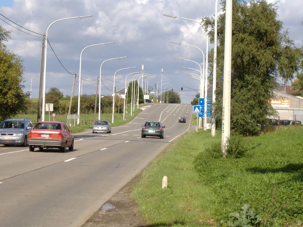
| David Brown | 18 Oct 2016 1:58 a.m. PST |
It really isn't flat. This pic is the last of a series that shows the rolling terrain up to the crossroads. There are a few of these rolling ridges that significantly break up the field.
[URL=http://s204.photobucket.com/user/dcrbrown/media/Quatre%20Bras%204_zps8vrrbwdc.jpg.html]
[/URL] DB |